

Many Highland place names have crossed the Atlantic with the early
settlers and still proclaim ties to the old country. Lairg, Brora,
Kildonan, Lochbroom, Gairloch, Dornoch, etc come to mind immediately.
To the best of my knowledge, Rogart was never recognized in the
settlements founded by its people.
The District of Earltown in Nova Scotia received several dozen Rogart
families among the early settlers with the balance coming mostly from
Clyne. Clyne is remembered obscurely through the name Cnoc Na Guidh,
a hillside so named in West Earltown after a similar hillside in Clyne.
This past year a 6km hiking trail was developed in the vicinity of an
unnamed hill, (mountain by local standards), overlooking Earltown. The
locals decided to name it the Rogart Mountain trail to commemorate the
early settlers from Rogart. There three old farms along the trail, now
in ruins, that were settled by Rogart natives Andrew Sutherland, Peter
Murray and William MacDonald. A burn and waterfall flowing through the
MacDonald farm has been named Leatteadh after a similar stream in
Rogart. (Mrs. MacDonald was a Matheson from Leatteadh).
Glen Matheson, Nova Scotia 2009
Many thanks to Glen for sending this news to us. Thank you also to the people of Nova Scotia for honouring the families of Rogart in this way.
Glen has also sent the trail map and notes which are full of interesting genealogical information.
Huge thanks also to Norris Whiston who was the force behind the creation of the trail.
Christine
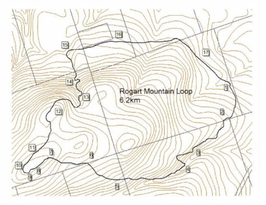

ROGART MOUNTAIN TRAIL – A 6.2 kilometer loop trail
Built by Cobequid Eco-Trails Society with support of NSHPP, the Municipality, & private and public landowners
1. Sugar Moon Farm. Boondock Maple Products was begun in the early 1970’s, and this camp, operated by Bob Williams and his sons, was built in 1986-87. In 1994 - 95, Scott Whitelaw and Quita Gray apprenticed the trade. They purchased it in 1996, renamed it Sugar Moon Farm, and expanded the camp in 2000-01.
2. Bonesetter’s Wall. The wall, in an open spaced maple hard woods, was built by the family of Peter “Bonesetter” and Elizabeth (Murray) Murray. Peter and Elizabeth and their two eldest children immigrated here from Rogart, Sutherlandshire, Scotland in August of 1822. Peter, though not a doctor, set the bones of horses and humans.Further information.
3. Christy and Alex’s Lookoff. Behind you is a wood of mostly rock maple, but includes yellow birch, striped maple, and spruce. White lady slippers and other hardwood forest flora also grow here. The lookoff has wilderness views, closest to you: of the hardwood of Boodle Hill in the center and the softwood of Gunn Hill on your right. It amazingly hides highway 311 and its car noise. Below the lookoff is a rock face which dates to 385 million ago, at the time when the Avalon Continental Plate was colliding with the Meguma Continental Plate forming part of Pangaea. Christy Murray was the daughter of the aforementioned Peter and Elizabeth Murray and Alexander MacKay was son of John “Post” MacKay and Ann Sutherland who lived on this property. Christy and Alex would have likely passed this way many times before they married in the 1850’s.
4. New Portugal Brook. Leaving the mixed forest, one descends into a spruce wood, of which many trees have died of old age. Further up, then down this same ravine another brook connects southward to the North River. Northward from here, this brook connects to the Waugh’s River. New Portugal was the original name of Earltown, showing in county and provincial records from 1819 through 1825. It was named after the participation by at least 20 local Scots in the Napoleonic Wars before they had immigrated. In 1807, a few of these were in Copenhagen, “Denmark”, and, from 1808 to 1813, all of these fought in Portugal and Spain. Ironically, one of our trail builders was born in Portugal. In 1819, in a pool of this brook, some Mi’kmaq women doused baby Catherine Sutherland, who lived at the base of this hill, in an old Mi’kmaq tradition to make the new born afraid of water.
5. Andrew’s Plateau. Within this area had been the fields and home of Andrew and Margaret (Murray) Sutherland. Along the brook, there is an old barbed wire fence which kept the sheep and farm animals from the brook. Andrew was one of those that fought in Portugal and Spain with the 94th regiment. Andrew and his “motherless” family immigrated from Rogart, Scotland in 1832. After arriving, Andrew married Margaret Murray who was also from Rogart. Their daughter, Catherine, born in 1835, married William Graham, whom resided here afterwards.
6. Catherine’s Lookoff. Here you have long distance eastward views of Dalhousie and Ephraim Mountains in Pictou County from which the Cape to Cape Trail will come. The lookoff borders the Sutherland’s property and ungranted land. A faintly discernable old road cuts behind here, heading to Ferguson Road in West Earltown. Catherine is the aforementioned Catherine (Sutherland) Graham.
(photo below Catherine's Lookout)

7. Rogart Vernal patch. South of the trail, in a flat spot is a wet, less-vegetated area that dries up in the summer.
8. Rogart Mountain North Lookoff. Elev. 1125 ft. Rogart had no name before and we named it for Rogart (meaning “high plateau” in Gaelic), Sutherlandshire, Scotland where at least four of the families who lived directly below this summit, came. The area has stunted beech, unique lichens and mosses. When leaves are off, one can see hills, the Northumberland shore, Prince Edward Island, and even, once in a while, the Prince Edward Island ferry.
9. Rogart Mountain South Lookoff. Here an old lone spruce is surrounded by stunted beech and maple. There are views of the Nuttby highlands, Upper North River, and Onslow’s hills.
10. Rogart Mountain West Lookoff. A grey stump and gnarly maple and beech are in your foreground and in the left part of your view are the towers of Nuttby Mountain, where the future Cape to Cape Trail will hopefully go. Farther away is Sugar Loaf Mountain and Tatamagouche Mountain, and further still is Prince Edward Island.
11. Rogart Grassland. A wood’s odd grassland is touched by the trail.
12. Leattie Rise (pronounced Letty). On this smooth round hill is a spacious old hardwood. From fall through spring, one can see the forests, farms, and blueberry fields of The Falls, Spiddle Hill, West Earltown, and Earltown. Further away is the Northumberland Strait.
13. Leattie Brook. Right below this brook is the farm of William and Jane (Matheson) MacDonald who each emigrated with their parents from Rogart, Scotland. William came from Rovie, Rogart in 1817 and Jane came from Leatty, Rogart by 1818. Leattie, Scotland, though not wooded, hills and rocky lands resemble Earltown’s.
14. Jane’s Falls. This is a thin falls but on a wide grand rock wall. This was named for the above Jane Matheson.
15. William and Jane MacDonald Foundation. William and Jane (Matheson) MacDonald likely came here in the early 1830s. Alex MacDonald, their son, was for whom the current road was named.
16. Robert and Nancy Munro Foundation. This was the foundation Robert and Nancy (Fraser) Munro’s home. Around 1901, the home became Alexander Douglas and Mary Elizabeth MacDonald’s.
17. Peter “Bonesetter” and Elizabeth (Murray) Murray Foundation. See #2.
Footnote: no. 12 Spiddle Hill is actually Cnoc Na Spidail, supposedly named for a hill in Strath Halladale. One of the settlers was Alexander Murray (Christy Sutherland), who settled up there in the 1830's after a series of removals from Rogart, Kildonan and eventually Strath Halladale. He was either an uncle or brother to Elspat Murray "Bonesetter".
Glen Matheson & Norris Whiston, Nova Scotia, 2008/9
Glen Matheson & Norris Whiston, Nova Scotia, 2008/9
No comments:
Post a Comment